Satellite positioning systems can be much more reliable if they correct for irregular ionospheric variations due to atmospheric gravity waves and geomagnetic storms, says PhD student Yahya Memarzadeh.
The ionosphere is a gift. Without this uppermost part of the atmos-phere, harmful solar radiation like extreme ultra violet light and x-ray would reach the Earth and make life impossible. And let’s not forget that the ionosphere also reflects radio signals, allowing broadcasters to transmit over large distances by ricocheting the signals between the Earth and the ionosphere.
But for precise positioning via satellites, the ionosphere is a pest. In this atmospheric layer, which mainly consists of oxygen and nitric oxide, most particles are ionised – split up into ions and electrons – by solar radiation. This plasma, as it is also called, changes the propagation velocity of the high frequency electromagnetic signals emitted by satellites and slightly bends the signals.
“That makes the ionosphere the largest error source for Global Navigation Satellite Systems, resulting in a positioning error of several tens of meters,” says PhD student Yahya Memarzadeh, of the faculty of Aerospace Engineering’s mathematical geodesy and positioning section.
Luckily there are reference stations spread around the world whose positions are known precisely. These stations measure the ionospheric induced delays on the satellite signals, before calculating what is known as the total electron content. This is a measure for the number of electrons that the satellite signals find along their path towards the Earth through the ionosphere.
The navigation system in our cars for example use this ionospheric data provided by reference stations to correct the signals from the satellites. That’s why we know our positions with a precision of several meters instead of tens of meters. Positioning with centimeter or even millimeter precision is also possible, if the signals are compared with those that nearby reference stations receive, but in such cases, one must measure over long periods and correct for errors.
Real time measurements with such precision are impossible at the moment, although Memarzadeh believes this is achievable if irregularities in the ionosphere can be modeled properly.
For this he developed an algorithm, which he described in his thesis, ‘Ionospeheric Modeling for Precise GNSS Applications’, that he will defend on December 8.
With the algorithm, the ground stations can map irregular fluctuations in the ionosphere caused by atmospheric gravity waves or solar winds (occurring especially during periods with higher solar activity). This is quite a feat, because these irregularities can be very local and temporal.
“Most of these irregularities had never been taken into account before,” says Memarzadeh. “And they really should have been, because the ionosphere is like an ocean – a dynamic ocean of plasma above our heads. Its density varies diurnally, but its surface also has wrinkles caused by atmospheric gravity waves or solar winds.”
If his technique works in the field, it could make it much easier to produce height maps, for instance. Researchers wouldn’t have to wait for long periods anymore at each point, but rather could move swiftly because each single measurement would be reliable. And this would be good news for oil companies; if they want to build a new rig, they can use a navigation satellite system to decide exactly where to place the next pole.
Memarzadeh believes that his model can be useful in a project led by his supervisor, Professor Peter Teunissen, in Australia. In 2006, Teunissen received a professorial fellowship from the Australian Research Council, called Next Generation Global Navigation Satellite Systems Ambiguity Resolution. The goal of this fellowship is to help new Global Navigation Satellite Systems, such as the EU’s Galileo, US’s modernized gps, Russia’s GLONASS and Japan’s QZSS, to challenge the well-known US global positioning system (gps).
De roeibond merkte de 34ste editie aan als meetmoment voor roeiers tot achttien jaar. Dat wil zeggen dat de resultaten medebepalend zijn voor plaatsing in bondsselecties.
Van de 360 startende boten waren er 100 gevuld met junioren. En dan was het ook nog eens twee dagen lang lente-achtig weer. Een mooier begin van het nieuwe roeiseizoen kon de organisatie zich niet wensen.
Het belang voor de junioren gaf een verhoogde status aan de Winterwedstrijden, waarvoor het steeds lastiger lijkt om echte toppers aan de start te krijgen van de vijfkilometerraces. Die passen niet in de voorbereiding op de aankomende bondstesten.
Wel aanwezig was het Proteus-talent Sander van Dijk, Nederlands ergometerkampioen bij de lichte roeiers in de categorie tot 23 jaar. Omdat de Delftenaar niet op gewicht was, moest hij zich inschrijven bij de zware roeiers. En die roeien harder.
Van Dijk startte in de twee zonder stuurman, met verenigingsgenoot Daan Boonstra, en eindigde als tweede. Van Dijk wil dit jaar een ticket bemachtigen voor het WK onder de 23 jaar. “Als hij zo doorgaat, heeft hij grote kans van slagen”, denkt organisatiecommissaris Bonnie van Vuure.
Een andere coryfee van Proteus, Arnoud Greidanus, wist in de skiff evenmin ‘blik’ te ‘trekken’. Hét succes voor Proteus was de winst in een gecombineerde boot met Okeanos van de overgangsroeiers in de lichte vier met stuurman. De zware vier van Laga boekte succes bij de senioren A.
De beker voor het hoofdnummer, de eerstejaars lichte achten, ging naar het Tilburgse Vidar. De winnende boot was opmerkelijk genoeg sneller dan de winnaar van de zware achten, eveneens een boot van Vidar.
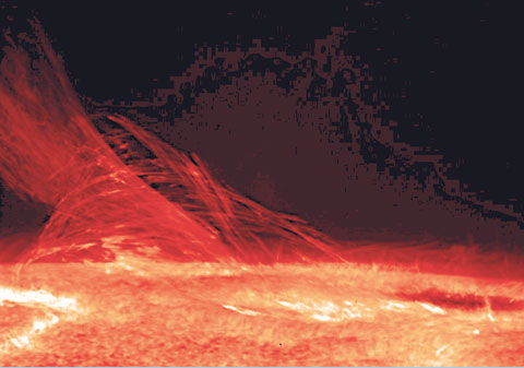
The ionosphere is a gift. Without this uppermost part of the atmos-phere, harmful solar radiation like extreme ultra violet light and x-ray would reach the Earth and make life impossible. And the ionosphere also reflects radio signals, allowing broadcasters to transmit over large distances by ricocheting the signals between the Earth and the ionosphere.
But for precise positioning via satellites, the ionosphere is a pest. In this atmospheric layer, which mainly consists of oxygen and nitric oxide, most particles are ionised – split up into ions and electrons – by solar radiation. This plasma, as it is also called, changes the propagation velocity of the high frequency electromagnetic signals emitted by satellites and slightly bends the signals.
“That makes the ionosphere the largest error source for Global Navigation Satellite Systems, resulting in a positioning error of several tens of meters,” says PhD student Yahya Memarzadeh, of the faculty of Aerospace Engineering’s mathematical geodesy and positioning section.
Luckily there are reference stations spread around the world whose positions are known precisely. These stations measure the ionospheric induced delays on the satellite signals, before calculating what is known as the total electron content. This is a measure for the number of electrons that the satellite signals find along their path towards the Earth through the ionosphere.
The navigation system in our cars for example use this ionospheric data provided by reference stations to correct the signals from the satellites. That’s why we know our positions with a precision of several meters instead of tens of meters. Positioning with centimeter or even millimeter precision is also possible, if the signals are compared with those that nearby reference stations receive, but in such cases, one must measure over long periods and correct for errors.
Real time measurements with such precision are impossible at the moment, although Memarzadeh believes this is achievable if irregularities in the ionosphere can be modeled properly.
For this he developed an algorithm, which he described in his thesis, ‘Ionospeheric Modeling for Precise GNSS Applications’, that he will defend on December 8.
With the algorithm, the ground stations can map irregular fluctuations in the ionosphere caused by atmospheric gravity waves or solar winds (occurring especially during periods with higher solar activity). This is quite a feat, because these irregularities can be very local and temporal.
“Most of these irregularities had never been taken into account before,” says Memarzadeh. “And they really should have been, because the ionosphere is like an ocean – a dynamic ocean of plasma above our heads. Its density varies diurnally, but its surface also has wrinkles caused by atmospheric gravity waves or solar winds.”
If his technique works in the field, it could make it much easier to produce height maps, for instance. Researchers wouldn’t have to wait for long periods anymore at each point, but rather could move swiftly because each single measurement would be reliable. And this would be good news for oil companies; if they want to build a new rig, they can use a navigation satellite system to decide exactly where to place the next pole.
Memarzadeh believes that his model can be useful in a project led by his supervisor, Professor Peter Teunissen, in Australia. In 2006, Teunissen received a professorial fellowship from the Australian Research Council, called Next Generation Global Navigation Satellite Systems Ambiguity Resolution. The goal of this fellowship is to help new Global Navigation Satellite Systems, such as the EU’s Galileo, US’s modernized gps, Russia’s GLONASS and Japan’s QZSS, to challenge the well-known US global positioning system (gps).
Heb je een vraag of opmerking over dit artikel?
delta@tudelft.nl
Comments are closed.