Advanced meteorology helps to reduce the costs of wind turbines. Plus it improves the power production forecast, making the operation more profitable.
After completing his master’s degree in meteorology, Maarten Holtslag MSc looked for a PhD post in either climate research or in wind energy. He ended up doing the latter at the FLOW research program on Far and Large Offshore Wind energy at TU Delft.
http://www.tudelft.nl/en/research/duwind/flow/
“We’re doing fundamental research on air flows, but at the same time the outcome is directly applicable to wind energy,” said Holtslag. FLOW aims at a cost reduction of 20% or more for offshore wind. Now that the Netherlands is on the verge of investing billions into around a thousand offshore wind turbines (3.500 megawatt extra before 2020), making offshore wind more efficient has a large societal impact.
http://delta.tudelft.nl/artikel/kamp-energieakkoord-op-koers/31428
In his PhD thesis, Holtslag shows that today’s turbines are sturdier than they need to be. He explained: “Wind shear (a large difference in wind speed with height, ed.) and turbulence both contribute to loads on a wind turbine that result in material fatigue. Consequently, wind turbines are built to resist those loads. But we have shown that high wind shear and strong turbulence do not coincide.”
 Summer and winter
Summer and winter
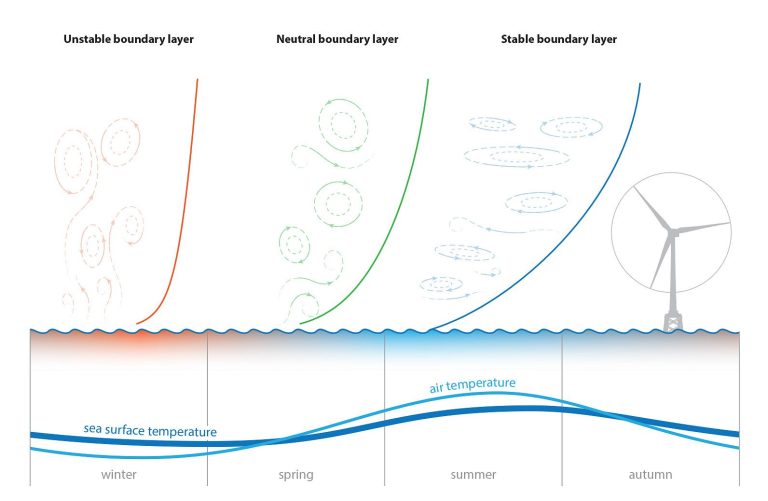
A drawing shows the general principle. During winter, the relatively warm seawater causes lots of turbulence in the air, which flattens the wind profile. In summer, the situation is reversed with little turbulence and significant wind speed differences with height.
The relationship between wind shear and turbulence, and the finding that they never coincide means that the tower is typically designed to withstand loads 30% higher than expected, and for the rotor this is about 10%. Holtslag estimates that his analysis can reduce the cost of offshore wind energy by 1%.
Precise and localised wind forecasts can also be used to improve the production estimates for a wind farm. Energy companies need to know the production in advance to make
an offer on the day-ahead power market. Falling short or overproducing may result in fines. Therefore, a better forecast is welcomed.
 Finecasting
Finecasting
The start-up Whiffle, which Holtslag has joined, is probably the first company to produce high detailed localized wind forecasts for wind farms commercially. Whiffle makes use of parallelized atmospheric calculations that were developed by Prof. Harmen Jonker and his team under the name Large Eddy Simulations. Jonker also joined the new start-up, together with co-founder Remco Verzijlbergh.
As an example, Holtslag mentions the low-level jets (LLJ). Those are local wind maxima with a typical speed of 6-15 m/s at a height of 140-200 metres. They can go on for hours. On the ground level, they pass unnoticed, but for a wind turbine, LLJs can contribute to substantial increases in power production. Although the name may sound exotic, LLJs occur pretty frequently, on average about once every 3-5 days on land (and less at sea). Standard forecasts will miss them, but ‘weather finecasting’, as done by Whifffle, will predict them and thus improve the production estimates.
–> Maarten Holtslag, Far offshore wind conditions in scope of wind energy, PhD thesis supervisor Prof. Gerard van Bussel (LR), Defence Jun 17th, 2016.


Comments are closed.